
Contact: contact@AntiqueMapArt.com, Phone: +61 (07) 3103 0391, Mobile: 0011 6723 51512 (Norfolk Mobile)
May not depict actual map.
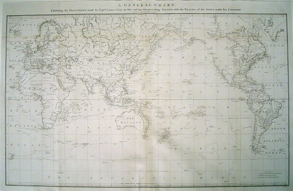
1784 - A General Chart: Exhibiting the Discoveries made by Capt.n James Cook in this and his two preceeding Voyages with the Tracks of the Ships under his Command
| Map maker | Size | Map ID | Condition |
|
James Cook
Henry Roberts | 920 x 580 mm | D1 / M40 / I39 | Has had some restoration. The top of the map has been trimmed very close and slightly into the title of the map "A General Chart". There are a number of small mended tears and wear along fold lines. The image however is clear and clean and is a very resonable example of this map. |
| Ask about this item | | SOLD |
This map is the centrepiece to the Cook collection and is said to have been the most accurate map of the world on its publication in 1784.
The map was drawn up by Henry Roberts after work that he conducted with James Cook before his death in 1779. Palmer is the accredited engraver for this edition. A few years latter William Faden would create an updated version of Palmer's edition, showing the new discoveries post 1784.
In 1779 Captain James Cook was killed in Hawaii after 10 years of exploring the Pacific. He had published his first two voyages in 1773 and 1777 which had been extremely popular the world over and were translated into a number of languages. After his death the crew returned home where his third voyage would be published after his death in 1784. In the large atlas accompanying the publication was the only official world map to convey his achievements. This map is in high demand and is now very difficult to find.
View map online on http://www.antiquemapart.com/map/40